About the environmental monitoring in the Lake Victoria region portal
A data portal for water quality and ecosystem health
The Lake Victoria Monitoring Portal is a collaborative initiative led by the UK Centre for Ecology & Hydrology (UKCEH) and the Kenya Marine and Fisheries Research Institute (KMFRI). This platform centralises environmental monitoring and modelling data, focusing on land degradation, ecosystem services, water quality, pollution levels, and ecological changes within the Lake Victoria region. The portal aims to provide researchers, policymakers, and stakeholders with accessible time series and spatial datasets to support evidence-based decision making on the sustainable management of the lake's resources.
The data presented in the portal originate from numerous projects and surveys, including the Second Lake Victoria Environmental Management Program (LVEMP II, 2012–2016), comprehensive pollution monitoring expeditions (e.g. 2015 and 2017), and government-sponsored environmental assessments (e.g. 2011, 2013, and 2017).
Additionally, gridded 90×90 metre square and sub-catchment maps of ecosystem services and pressures were generated using the Stanford Natural Capital Project's InVEST modelling platform. These maps cover the full extent of Lake Victoria's catchment for the years 2000, 2005, 2010, 2015 and 2022.
Also included is a map of the suitability of different areas of the Kenyan part of Lake Victoria for developing cage fish farms.
This integrated approach will enable a more holistic understanding of water quality and ecological trends across the lake and its surrounding catchment. More datasets will be added from on-going and future research and monitoring activities conducted by KMFRI, UKCEH, and other contributing agencies.
Purpose and audience
The portal is designed to serve multiple purposes:
- For researchers and scientists, it acts as a repository of high-quality data to support academic studies and environmental modelling.
- For policymakers, it offers insights into key environmental challenges, helping to shape sustainable intervention strategies.
- For the public, it fosters transparency and awareness about the environmental health and status of Lake Victoria, a vital resource for millions of people.
The scientific briefs are particularly useful for identifying trends, understanding ecosystem pressures and responses, and evaluating the effectiveness of past interventions. They consolidate the available data into clear, actionable formats for use in environmental assessments and planning.
Key features and how to use the portal
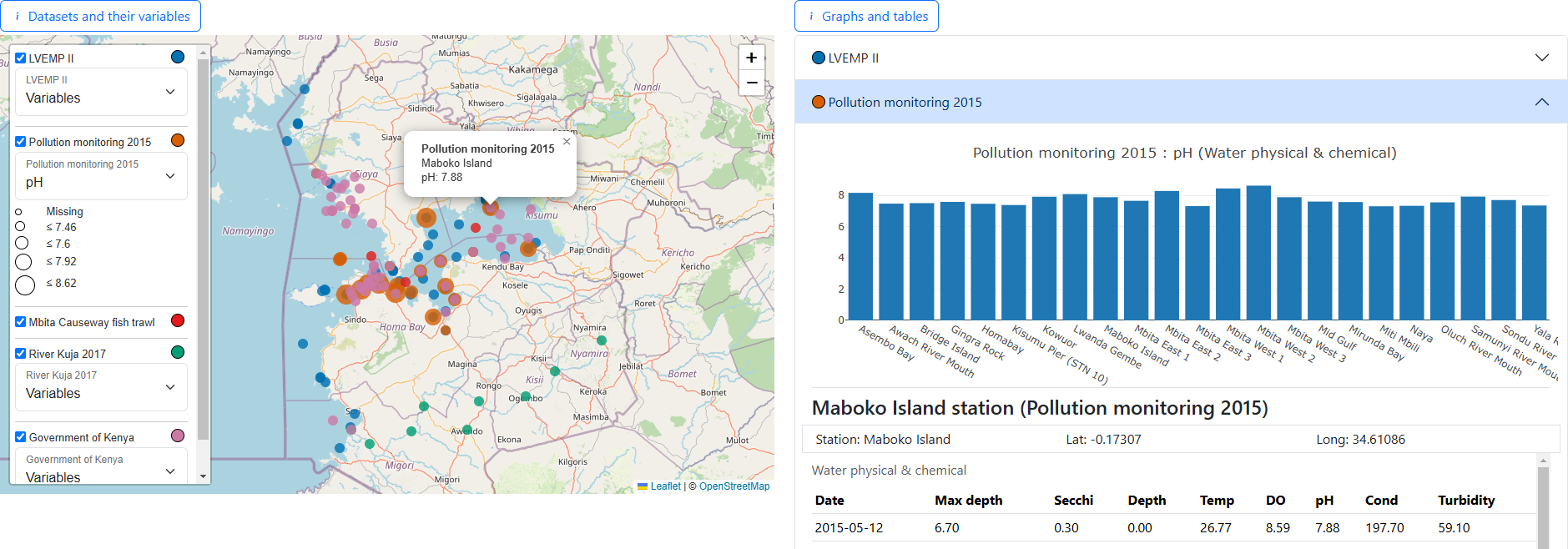
- Layer control: Users can toggle datasets on and off using the 'Map layers'
 icon. Each dataset is associated with mapped locations displayed as markers on the map.
 - Variable selection: Selecting a variable for a dataset (e.g. dissolved oxygen, pollution concentrations) dynamically adjusts the associated marker sizes to reflect the recorded values. Graphs and time-series data for all locations or a selected location are generated automatically.
- Data exploration: Within the datasets, users can view:
- Graphs showing spatial variations of the selected variable.
- Detailed data tables for selected locations.
- Time-series trends of variables for individual locations.
By offering interactive tools for data visualisation and analysis, the portal bridges the gap between raw data and actionable insights.
Links to dataset sources
The gridded and sub-catchment map layers presented in the portal are available to download and use under the terms of the UK's Open Government License from the Environmental Information Data Centre via the following links:
- Sharps, K., Bisht, T., Feeney, C., Thomas, A., & May, L. (2025). Ensemble of land and freshwater ecosystem services mapped for Lake Victoria's catchment area: 2000–2022.
- Sharps, K., Feeney, C., Bisht, T., Thomas, A., & May, L. (2025). Erosional impacts on soil and freshwater nitrogen and phosphorus dynamics in Lake Victoria's catchment area: 2000–2022.
Acknowledgements
Development of the web portal, as well as the generation of gridded and sub-catchment map datasets, were supported by the UK Research and Innovation Natural Environment Research Council as part of the NC-International programme [NE/X006247/1] delivering National Capability.